Acoustic Arc AR0810 Radarbox System User Manual AirNav RadarBox 2007 Manualx
Acoustic Arc International Ltd. Radarbox System AirNav RadarBox 2007 Manualx
UserManual.wiki
>
Acoustic Arc
>
AR0810 User Manual
Users Manual
Navigation menu
Upload a User Manual
Namespaces
Wiki Guide
HTML
PDF
Info
Views
User Manual
Discussion / Help
Navigation
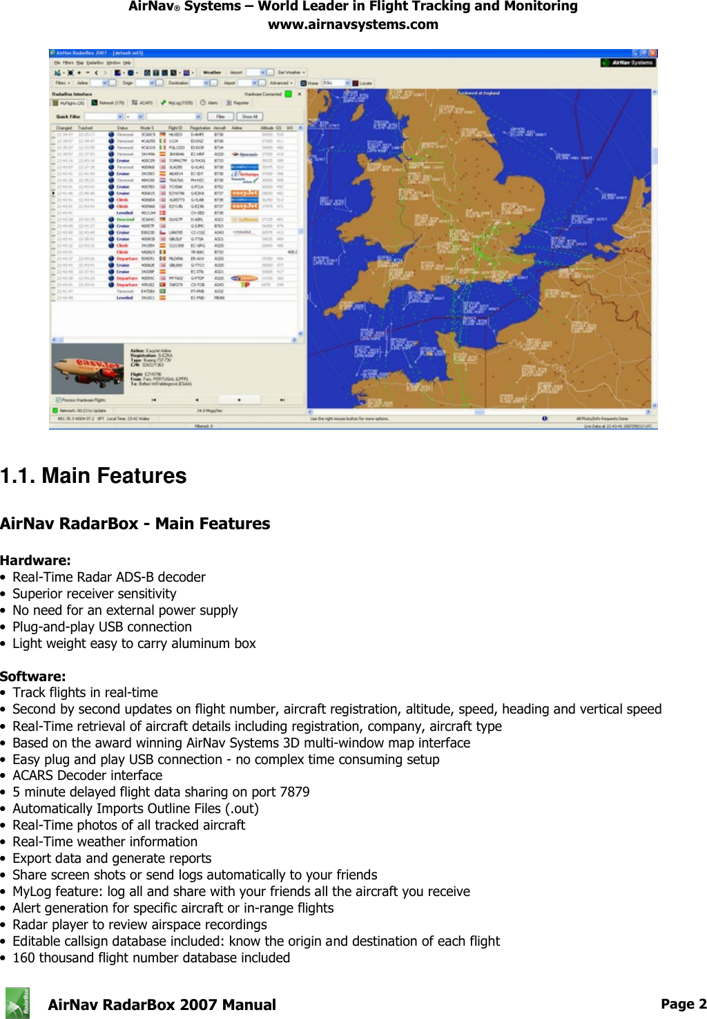
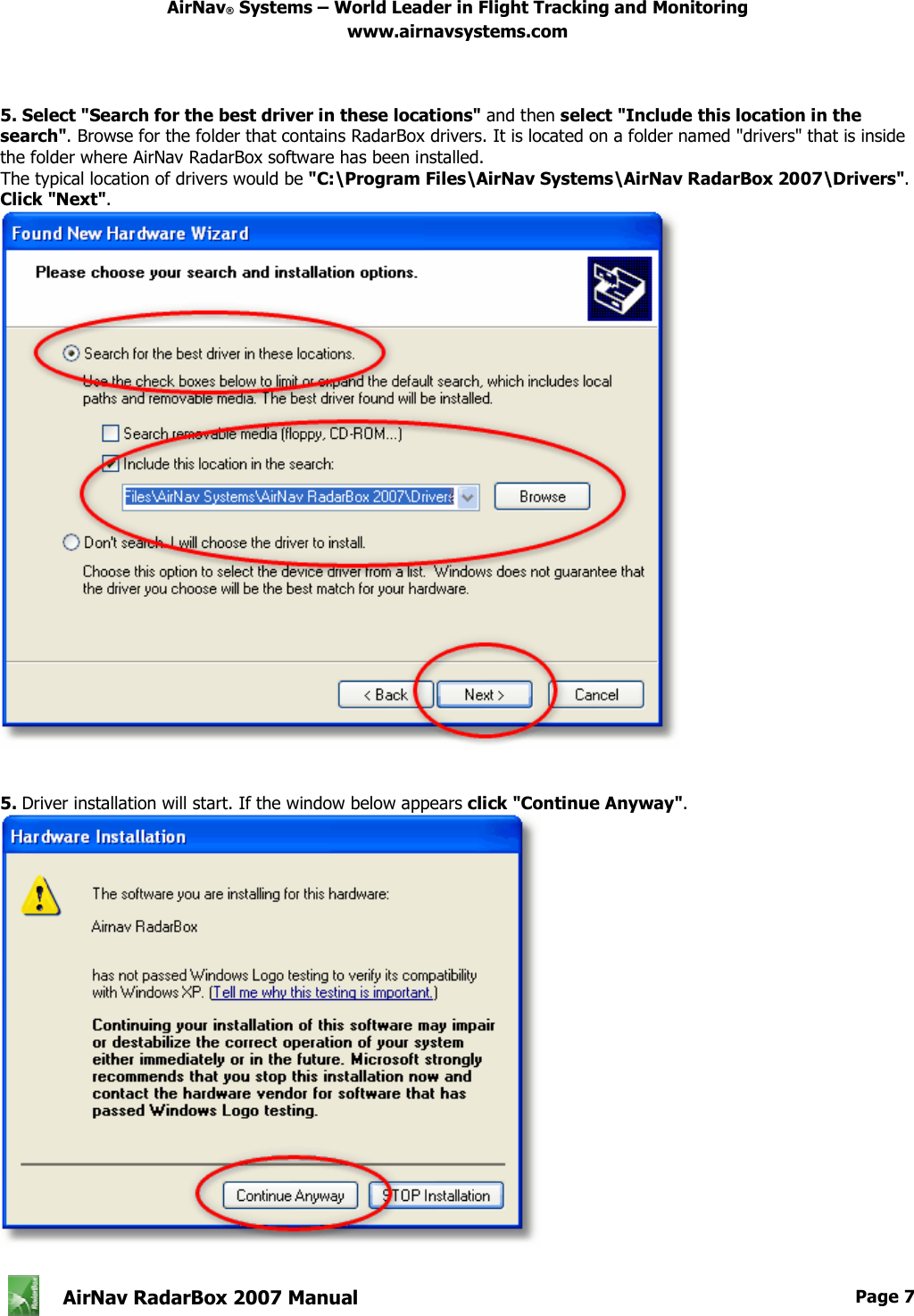
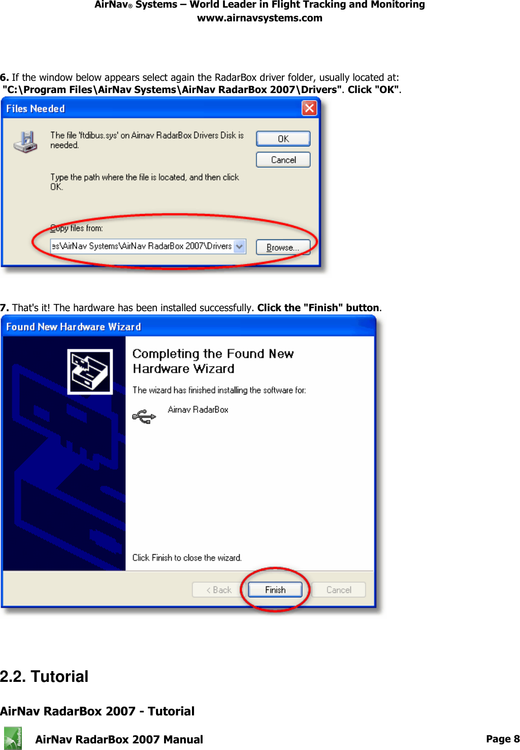
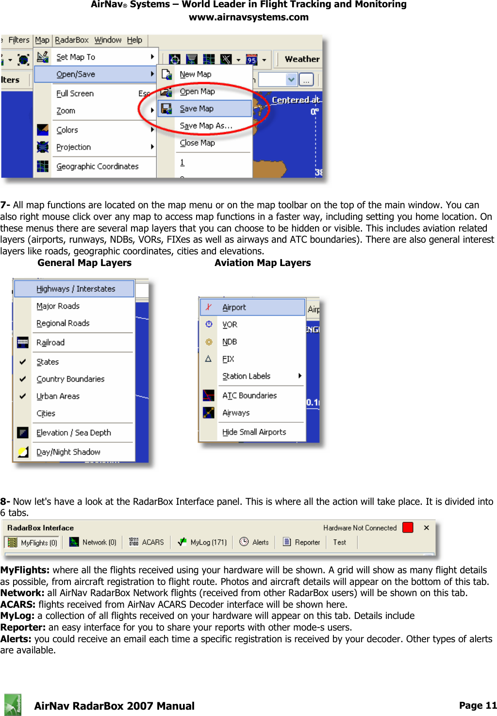
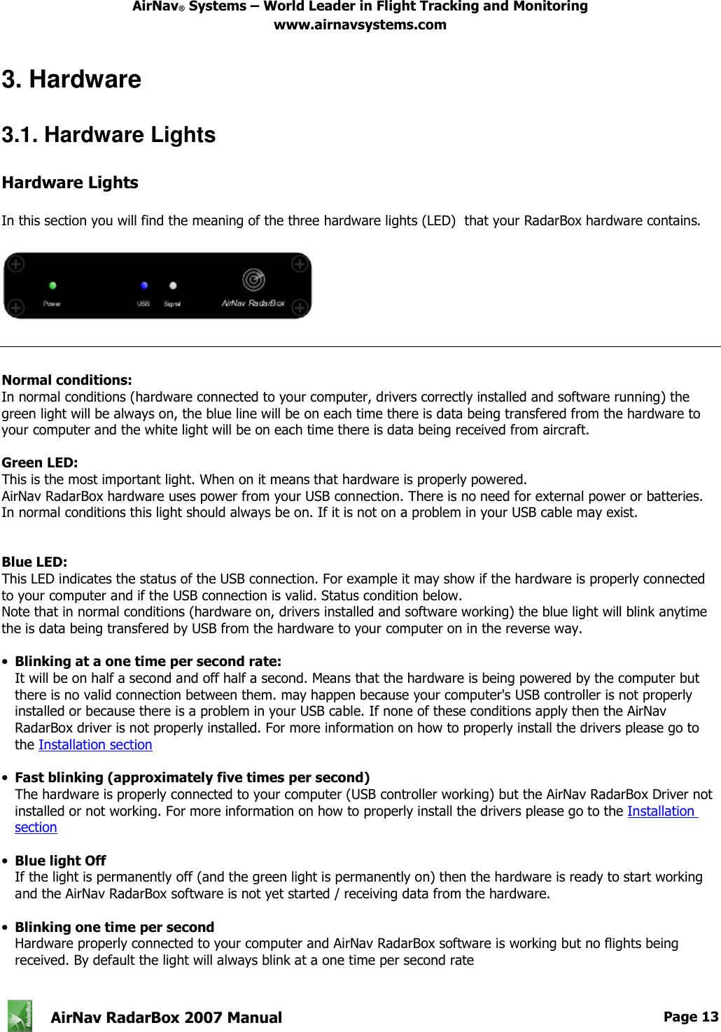
![AirNav® Systems – World Leader in Flight Tracking and Monitoring www.airnavsystems.com AirNav RadarBox 2007 Manual Page 9 AirNav RadarBox 2007 tutorial is a group of step by step instructions that will guide you through the most important application features. Note: information between [...] means that the command mentioned can be found in AirNav RadarBox 2007 Menus. Example: [Tools|Internet|Download Updated Data Now] points you to click on Tools menu, Internet topic, Download Updated Data Now subtopic. Step by Step Tutorial 1- Start the software using the windows Shortcut created on your Start Menu or Desktop. 2. The Welcome Window will be shown. Enter your Email/Username and Password. Click the "Start" button after this. You can check the Remember password checkbox in case you do not want to type your personal details every time you start the software. The connection to the Hardware will be started and if you are a subscriber of AirNav RadarBox Network feature, the software will try to download network data. 3- The main software window with a world map will be shown as illustrated below. Dynamic 3D maps are one of AirNav RadarBox 2007 most important features. You are now going to explore some of the capabilities.](https://usermanual.wiki/Acoustic-Arc/AR0810/User-Guide-1006713-Page-10.png)
![AirNav® Systems – World Leader in Flight Tracking and Monitoring www.airnavsystems.com AirNav RadarBox 2007 Manual Page 10 4- First task: you will center the map at your home location, zoom in and save it as your default map. To center the map at any location let's use the "Locate" feature. It easily centers the map on any airport, city or navigation facility all over the world. Imagine you are located near London Heathrow Airport. Enter "EGLL" on the locate box. This box it at the top of the main screen as on the screen shot below. After this click the Locate button. The map will now be panned so that London appears on the center. 5- Now Zoom in a more detailed view of the London area is shown. You can do this by clicking the zoom in button on the map toolbar. The easiest way to pan/zoom your maps is by using your mouse buttons. Learn more here. 6- Save your map by going to [Map |Open/Save | Save Map]. Answer Yes to the "Are you sure you want to overwrite your default map file?". This map will be the one that will be always shown after the application is started.](https://usermanual.wiki/Acoustic-Arc/AR0810/User-Guide-1006713-Page-11.png)
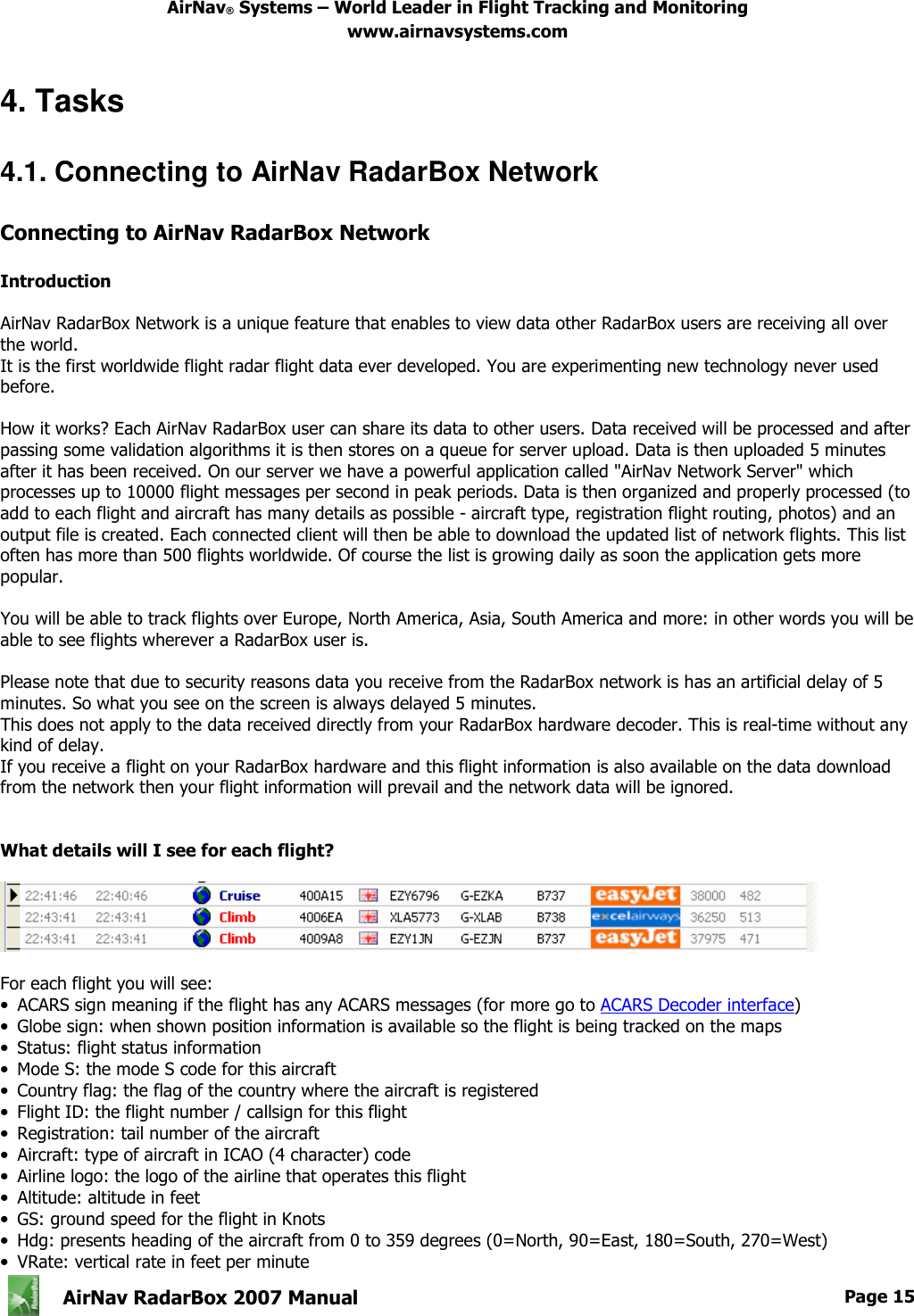
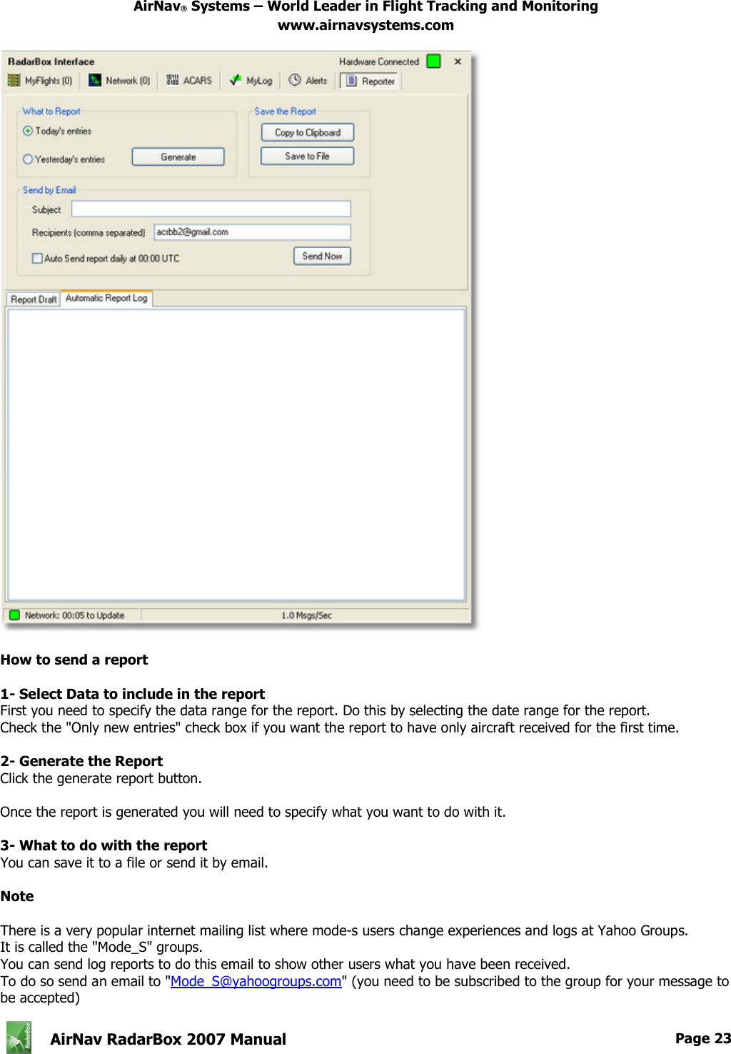
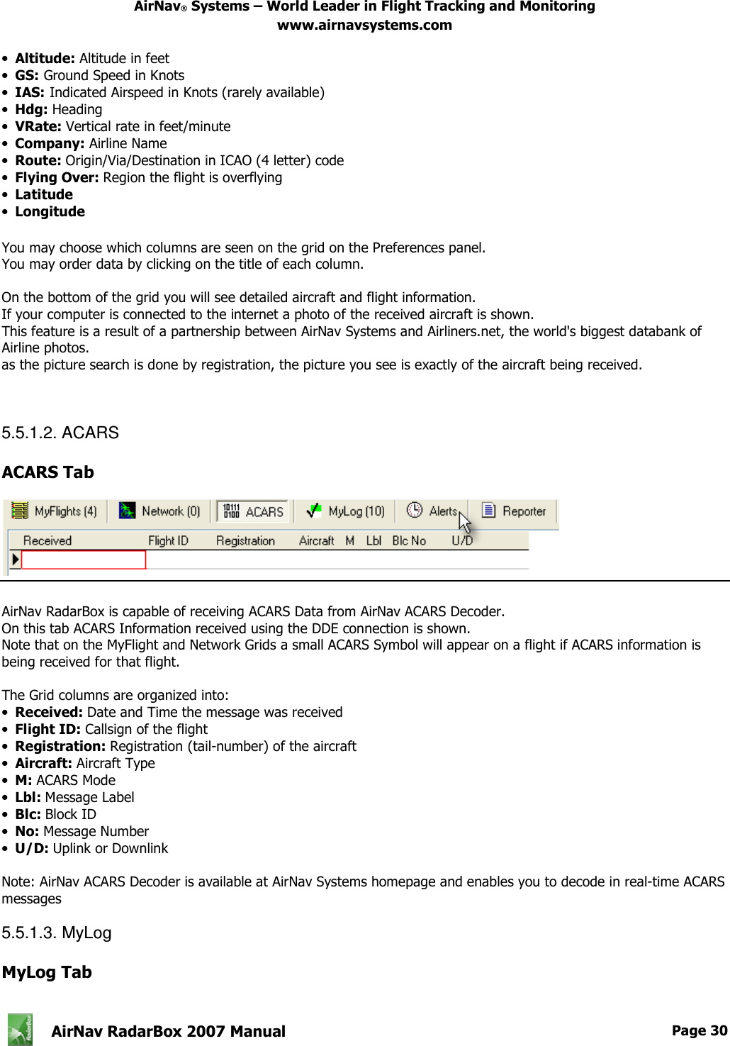
![AirNav® Systems – World Leader in Flight Tracking and Monitoring www.airnavsystems.com AirNav RadarBox 2007 Manual Page 16 • Route: origin and destination airports and sometimes stops Connecting to the Network To connect to AirNav RadarBox network you need to have your RadarBox hardware connected to your computer. After this open the RadarBox Interface if it not already open, go to the Network tab and check the "Get flights from RadarBox Network" check box. Watch on the bottom of the RadarBox Interface panel, the connection status. Data is downloaded each 30 seconds. Note that you will have to be a registered user of the software and have an active AirNav RadarBox account to be able to receive network flights. You can do this at the main menu [RadarBox | Network Account Information] To subscribe to AirNav RadarBox Network please visit AirNav RadarBox Order page New users have free access to the network during the first year. 4.2. Connecting to AirNav ACARS Decoder Connecting to AirNav ACARS Decoder Introduction AirNav RadarBox can work in conjunction with AirNav decoder. This way you will be able see ACARS messages for the flight you are tracking. This way AirNav RadarBox is the first radar decoder application ever to have an ACARS interface included. Data is passed from AirNav ACARS Decoder to AirNav RadarBox using a simple Windows DDE (Dynamic Data Exchange) interface. All is done in a transparent way so all the user does not need to do anything. For more information on ACARS please read the bottom of this topic. Connecting to AirNav ACARS Decoder When you start AirNav RadarBox it will detect if AirNav ACARS Decoder is running and if that is the case, connect to it automatically. Anyway you can manually force a connection to AirNav ACARS Decoder using AirNav RadarBox menu at [File | AirNav ACARS Decoder Connection On/Off] Screen Shot of AirNav ACARS Decoder 2. For more information visit AirNav Systems Homepage.](https://usermanual.wiki/Acoustic-Arc/AR0810/User-Guide-1006713-Page-17.png)
![AirNav® Systems – World Leader in Flight Tracking and Monitoring www.airnavsystems.com AirNav RadarBox 2007 Manual Page 17 What details will I see for each flight? All the flight details received from AirNav ACARS Decoder will be shown on the RadarBox Interface, ACARS Tab. For each flight you will see: • Received: time of message reception • Flight ID: the flight number / callsign for this flight • Registration: tail number of the aircraft • Aircraft: type of aircraft in ICAO (4 character) code • M: ACARS Mode • Lbl: message Label • Mode S: the mode S code for this aircraft • Blc, No: block ID, and message number • U/D: if the message is an uplink or downlink What is ACARS? ACARS ([A]ircraft [C]ommunication [A]ddressing and [R]eporting [S]ystem) is a digital data link system transmitted via VHF radio which allows airline flight operations departments to communicate with the various aircraft in their fleet.](https://usermanual.wiki/Acoustic-Arc/AR0810/User-Guide-1006713-Page-18.png)
![AirNav® Systems – World Leader in Flight Tracking and Monitoring www.airnavsystems.com AirNav RadarBox 2007 Manual Page 18 This VHF digital transmission system, used by many civilian aircraft and business jets, can be likened to "email for airplanes," as the registration of each aircraft is it's unique address in the system developed by aeronautical radio giant ARINC (Aeronautical Radio, Inc.). Traffic is routed via ARINC computers to the proper company, relieving some of the necessity for routine voice communication with the company. With ACARS, such routine items as departure reports, arrival reports, passenger loads, fuel data, engine performance data, and much more,can be requested by the company and retrieved from the aircraft at automatic intervals. Before the advent of ACARS, flight crews had to use VHF to relay this data to their operations on the ground. The ACARS system is comprised of the following elements: 1- The Airborne Subsystem, onboard the aircraft, which consists of the: Management Unit Receives ground-to-air messages via the VHF radio transceiver, and also controls the replies. Control Unit is the air crew interface with the ACARS system, consisting of a display screen and printer. 2- The ARINC Ground System, which consists of all the ARINC ACARS remote transmitting/receiving stations, and the ARINC computer and switching systems. 3- The Air Carrier C2 (Command and Control) and Management Subsystem, which is basically all the ground based airline operations such as operations control, maintenance, crew scheduling and the like, linked up with the ACARS system. Messages can be categorized in two ways: "Downlinks" which are those ACARS transmissions which originate in the aircraft, and "uplinks" are those messages sent from the ground station to the aircraft. A typical series of ACARS transmissions will look something like this example of United 767-300ERs departing from Washington Dulles International (IAD): ACARS mode: 2 Aircraft reg: .N651UA Message label: QF Block id: 1 Msg. no: M82A Flight id: UA0978 Message content:- IAD2241FRA -----------------------------------------------------------[05/08/1997 22:41] The message label QF refers to an ACARS OFF report/message. The nose gear struts are now retracting, and the ACARS system duly notes this event as the off time. Departure airport and destination station are noted to the left and right of the OFF time respectively. ACARS mode: 2 Aircraft reg: .N651UA Message label: SA Block id: 2 Msg. no: S82A Flight id: UA0978 Message content:- 0LS224151V -----------------------------------------------------------[05/08/1997 22:41] In this example, we see a downlink response to an uplinked weather report,sent by crew request or automatically by the flight operations. ACARS mode: 2 Aircraft reg: .N651UA Message label: H1 Block id: 3 Msg. no: D89A Flight id: UA0978 Message content:- #DFBE13C24651'''''''''''' 8 5972240TO 132202 294 25103269 220 1440 947 520 97418600250107179 5341565144173014923812143 262528 11 0201 -----------------------------------------------------------[05/08/1997 22:42]](https://usermanual.wiki/Acoustic-Arc/AR0810/User-Guide-1006713-Page-19.png)
![AirNav® Systems – World Leader in Flight Tracking and Monitoring www.airnavsystems.com AirNav RadarBox 2007 Manual Page 19 ACARS mode: 2 Aircraft reg: .N651UA Message label: H1 Block id: 4 Msg. no: D89B Flight id: UA0978 Message content:- #DFB89 0 0 0 661 147 47 A6F003980000080000D2A0000000000000000000002A3 B4F4039C8000080000D2A0000000000000000000002A3 1440 950 536 -----------------------------------------------------------[05/08/1997 22:42] In this series of two messages, we see a takeoff (TO) engine performance report. ACARS mode: 2 Aircraft reg: .N651UA Message label: H1 Block id: 5 Msg. no: D89C Flight id: UA0978 Message content:- #DFB97418853250111173 5541565144173614933782162 261527 15 0201 89 -2 0 0 671 146 27 A6F4039C8000080000D32000000000000000000000423 -----------------------------------------------------------[05/08/1997 22:42] ACARS mode: 2 Aircraft reg: .N651UA Message label: H1 Block id: 6 Msg. no: D89D Flight id: UA0978 Message content:- #DFB B4F083980000080000D32000000000000000000000423 -----------------------------------------------------------[05/08/1997 22:42] The engine performance data continues to be downlinked in the above three transmissions. ACARS mode: 2 Aircraft reg: .N651UA Message label: 5Z Block id: 7 Msg. no: M83A Flight id: UA0978 Message content:- /R3 IADFRA 0978-05 IAD -----------------------------------------------------------[05/08/1997 22:44] This is a downlink response to an uplinked HOWGOZIT report (shown below), which is a United Airlines flight data report format: ACARS mode: 2 Aircraft reg: .N658UA Message label: RA Block id: J Msg. no: QUHD Flight id: QWDUA~ Message content:- 10978-23 HOWGOZIT UA978 IADFRA IAD 2214/2249 887A SWANN 2259 37 849 BROSS 2301 37 839 OOD 2307 37 815 RBV 2312 37 801 ACK 2337 37 757 WHALE 2354 37 728 BANCS 0108 37 -----------------------------------------------------------[23/07/1997 22:51]](https://usermanual.wiki/Acoustic-Arc/AR0810/User-Guide-1006713-Page-20.png)
![AirNav® Systems – World Leader in Flight Tracking and Monitoring www.airnavsystems.com AirNav RadarBox 2007 Manual Page 20 Waypoints are shown in the lefhand column, just below the OUT and OFF times from IAD. OUT refers to doors closing on the aircraft at the gate, and OFF refers to time of departure as outlined above. ETAs at the waypoints along the route are shown in the middle column, requested/expected flight level next and fuel remaining figures are shown in the right hand column. ACARS mode: 2 Aircraft reg: .N651UA Message label: _ Block id: 0 Msg. no: S87A Flight id: UA0978 -----------------------------------------------------------[05/08/1997 22:44] This is a frequent vistor to the ACARS screen, a signal that the aircraft is in the process of receiving uplinked messages. ACARS mode: 2 Aircraft reg: .N651UA Message label: H1 Block id: 4 Msg. no: D90A Flight id: UA0978 Message content:- #DFB/PIREPUA.E22C246510978KIADEDDF 8 5972250CL 122 DATA NOT AVAILABLE 38.9850 -77.46532241 1757 18.0324 14 39.0942 -77.51132243 6802 -----------------------------------------------------------[05/08/1997 22:50] ACARS mode: 2 Aircraft reg: .N651UA Message label: H1 Block id: 5 Msg. no: D90B Flight id: UA0978 Message content:- #DFB 7.5332 13 39.1518 -77.22502247 11805 -4.3307 17 -----------------------------------------------------------[05/08/1997 22:50] These two messages are position and weather data downlinked from the aircraft automatically to the ground station. ACARS mode: 2 Aircraft reg: .N642UA Message label: H1 Block id: 9 Msg. no: F39A Flight id: UA0970 Message content:- #M1BPOSN39092W076136,SWANN,215516,230,GOLDA,215624,BROSS,M21,28214,958/TS2155 16,100897B166 -----------------------------------------------------------[10/08/1997 21:55] This is a good example of a position report along the aircraft's flight route. In this case, United flight 970 is a North latitude 39.09.2 and West longitude 76.13.6, which happens to be the waypoint named SWANN, and they were over SWANN at 2155.16 UTC, at FL230 (Flight Level 230 or 23,000 feet), and they are estimating next waypoint GOLDA at 2156.24, next position BROSS. Outside air temperature is a minus 21, wind 282/14. Note: you may find ACARS detailed information at the world's best ACARS information source, ACARS Link Page 4.3. Creating Alerts Creating Alerts](https://usermanual.wiki/Acoustic-Arc/AR0810/User-Guide-1006713-Page-21.png)
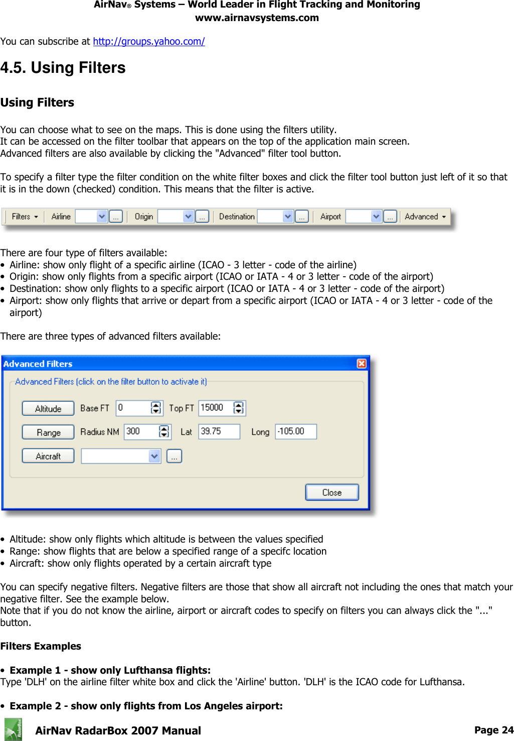
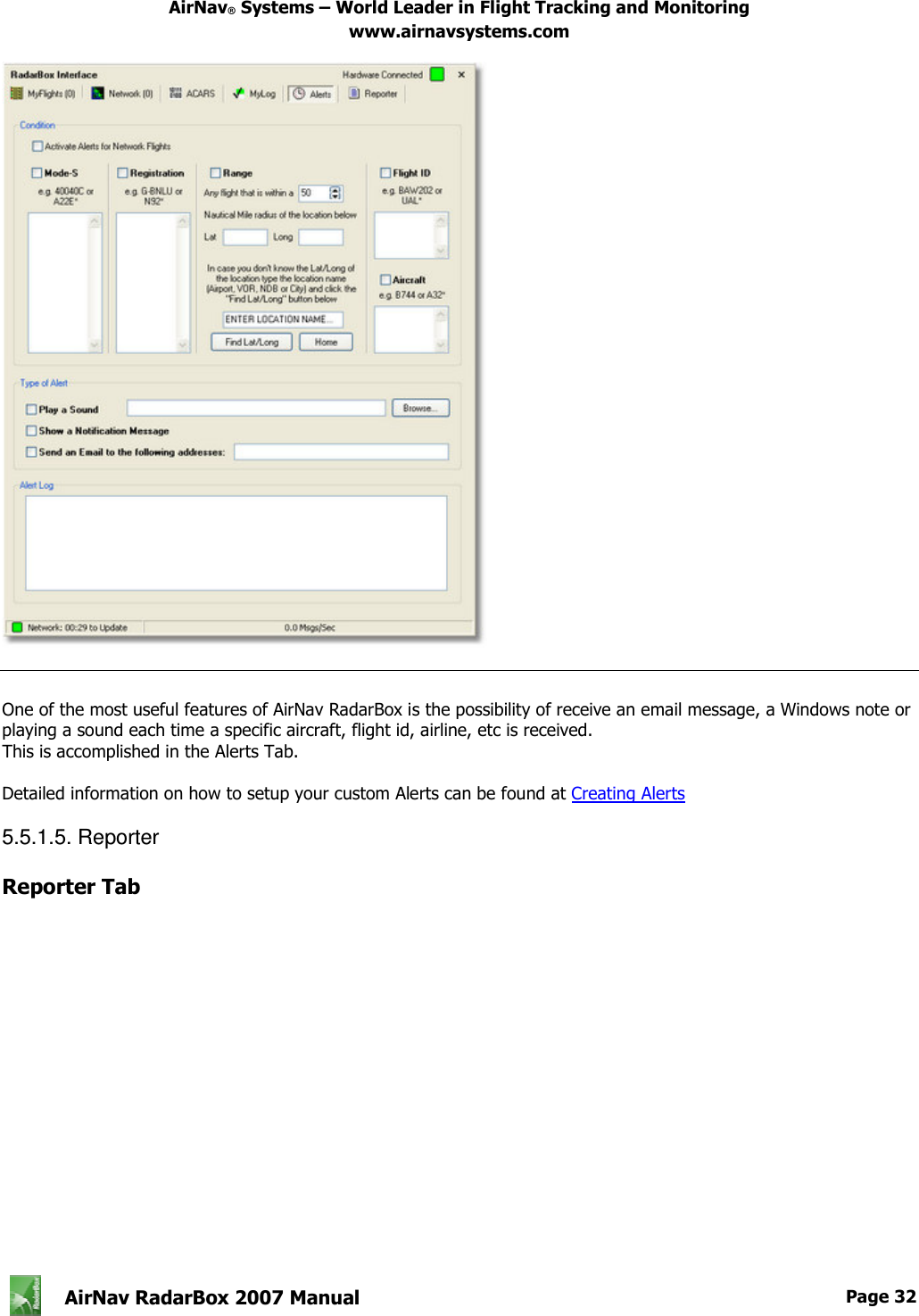
![AirNav® Systems – World Leader in Flight Tracking and Monitoring www.airnavsystems.com AirNav RadarBox 2007 Manual Page 21 One of the most important features of AirNav RadarBox is that you can program the software to trigger alerts for certain circumstances. For example, you can have the program to automatically send an email message when British Airways flight 272 is received. The Alert feature can be accessed on the RadarBox Interface. If it not shown open it at the program's menu [RadarBox | Interface | Show/Hide]. How it works? The alert feature is divided in two parts: • Conditions that will trigger an alert • Type of Alert There are five types of conditions to trigger an alert: • Mode-S: when an aircraft with a specific mode-s has been received an alert is triggered • Registration: when a specific registration is received • Range: when a flight is less that a defined number of miles from a specified location • Flight ID: to trigger an alert when a defined flight number is received • Aircraft: when an aircraft type appears on the system](https://usermanual.wiki/Acoustic-Arc/AR0810/User-Guide-1006713-Page-22.png)